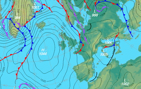
The isobars (lines
with 1032, 1028, 1024, 1020...) join points of equal pressure, measured
in mb (millibars).
Anticyclones are areas of high
pressure (marked H), often associated with settled weather, while
Depressions are area of low pressure (marked L), associated with
unsettles, wet and windy weather.
Warm fronts (red lines) are where
warm air is rising over cooler air - usually this means cloud and rain,
Cold fronts (blue lines) are where cold air is pushing underneath
warmer air - often giving cloud, rain followed by showers.
Air would like to travel from area with
high pressure to areas with low pressure, but like water running away
down your bath or sink plughole, it has to spiral its way around rather
than going directly from high to low! This is an effect of the earth's
rotation (the Coriolis force).
Consequently air travel roughly along the
line of the isobars, but veering slightly towards the low and away from
the high pressure areas.
The closer the isobars, the stronger the
wind will be, the further away they are, the lighter the wind will be.
Generally, isobars are tightly wrapped
around low pressure (so it is windy there as well as wet and cloudy),
but well apart around high pressure (so winds there are light breezes or
calm).